Read on for a detailed account of our third day trekking the Annapurna Circuit. Today, we walked from Jagat to Dharapani, covering a distance of 15km in just over 7 hours. We were treated to stunning scenery, impressive waterfalls and odd rock formations. We also almost got washed away by a flood!
The third day walking the Annapurna Circuit was full of beautiful vistas, suspension bridges and lush greenery. It was also the only time we got caught by the rain and spent a significant part of the day wet. Today’s route would take us from Jagat to Chyamche, from Chyamche to Tal and finally from Tal to Dharapani. Starting at 1300m, we would ascend to 1860m by the end of the day. It’s a 15km and around 7 hours 15 min walk from Jagat to Dharapani including all stops.
Read on for my experiences, tips and advice from day three hiking the Annapurna Circuit Trek.

Day Three: Jagat to Dharapani on the Annapurna Circuit
Jagat (1300m) – Chyamche (1430m) – Tal (1700m) – Dharapani (1860m)
Distance: 15km
Time: 7 hrs 19 minutes (08:03 – 15:22)
Jagat to Chyamche
Jagat (840m) – Chyamche (1310m)
Distance: 4km
Time: Around 1 hour
After breakfast of banana porridge and instant coffee, we packed our bags and set off from Jagat. Most of today’s walk followed the river closely and the sun was shining as we made our way to the outskirts of the village. Just a few minutes outside Jagat, there is an option to take a short detour from the road, signposted by the usual white and red markings. The detour consists almost exclusively of stairs but it provides a nice alternative to the dirt road. It’s probably one of the harder sections of the day – the stairs are steep and there is a lot of going up and down. It’s a tough start to the day but luckily the entire section only takes less than 20 minutes.
Soon after, we were back on the road and continued on following it. There are some waterfalls on the other side of the river and we made stops to take photos. The big waterfall just outside of Chyamche has the official height of 202 metres and is pretty impressive! There is not much point in stopping in Chyamche as it only takes about an hour to get here. Some people following alternative itineraries choose to stay here overnight but our day was just starting!


Chyamche to Tal
Chyamche (1385m) – Tal (1700m)
Distance: 5km
Time: Around 2 hours
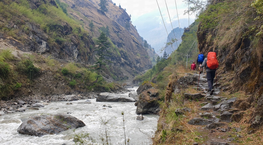
We descended the steps towards the water and crossed the raging river via the first suspension bridge of the day. The path threaded its way under huge boulders and past more waterfalls. The spectacular verdant landscape was not something we expected to encounter on the trek and we took time to take in the views as the path climbed higher above the river. Small lizards darted in and out of the undergrowth around us and we passed goatherds and livestock while beautiful mountain vistas opened up all around us.
We reached a point from which we could see a huge cone-shaped cliff with a road hewn into its side, precariously close to a huge drop into the ravine/river. Cars, dwarfed by the sheer size of the rock, looked tiny as they navigated their way carefully around the formation. We descended into another green valley – with the abundance of trees and grass, you would be hard pressed to guess what country you were in! A small tea shop overlooked the incredible landscape and we joined a few other trekkers for a short break. Goats here vastly outnumbered people and we were quickly surrounded by a small herd!
Continuing on, we soon came to a gate welcoming us to Manang district. We were still a few days away from Manang itself but it was good to see we were making progress. We descended towards the river and made our way to the village of Tal where we stopped for a long lunch. I opted for fresh vegetable soup, Tibetan bread and some plain rice.


Tal to Dharapani
Tal (1700m) – Dharapani (1860m)
Distance: 3km
Time: Around 2 hours 10 minutes
After taking our time eating and relaxing, it was time to head out. Clouds were beginning to gather and we didn’t want to get caught out by the rain. We headed out of Tal along the path which was now squeezed between the river and the imposing cliffs. The weather was really starting to turn for the worse so we scrambled to get out our rain gear and protect our sleeping bags by putting them in plastic bags.
The skies opened up and rain began to lash down on us. The path was beginning to get slippery in places so we decided to cross over to the road for a while. It was wider and we thought we might get a bit more traction so crossed over at the next available suspension bridge. It didn’t prove to be that much better. We had to navigate a washed-out section as water gushed down the cliffs and across the road forming a mini-river. We had to use our sticks to precariously balance on slippery rocks as we navigated the obstacle while trying not to get our feet soaked.
Hazard successfully navigated, we continued past small villages and terraced fields before tackling another suspension bridge. We crossed back over to the walking path to get away from the road again. This next section of the path passed dangerously close to the rushing river bolstered by all the rain. We took extra care walking on slippery rocks to to avoid tumbling into the river!
Eventually, we reached Dharapani just as the rain stopped. We dropped our bags and dried our gear while enjoying hot tea in the common area.


Exploring Thonche village
I fancied some thinking time so took a walk across the river and explored a small village of Thonche. I passed a colourful Mani Wall and spent some time taking in the landscape next to the river. This is actually where the Manaslu Trek joins the Annapurna Circuit before finishing in Besisahar.
I headed back to the guesthouse to enjoy a much-deserved dinner. The skies opened up again and it continued to rain throughout the night, the sounds of thunder reverberating around the valley.


Jagat to Dharapani Key Notes
- The scenery is at its best between Chyamche and Tal – look out for waterfalls, incredible rock formations and some precipitous drops!
- Despite the elevation gain, this isn’t a super tough day. The most challenging bit is probably those stairs at the beginning of the day. Remember: they are optional!
- There is an ACAP checkpoint close to the edge of the village. You can check in with the authorities either as you arrive or the following day as you leave Dharapani.
Staying in Dharapani: 3 Sisters Guesthouse
The guesthouse is on the edge of town, past the ACAP checkpoint and right by the path to the suspension bridge that leads to Thonche. The rooms are pretty standard and there is pretty spacious common area. Squat toilets but hot showers are available. We didn’t think it was anything spectacular but was fine for the night. Bear in mind that showers are accessed via stairs which are not covered so take care not to slip if it’s been raining.
Up Next: Dharapani to Chame on the Annapurna Circuit – Day 4

Check out my other Annapurna Circuit posts
- Annapurna Circuit Itinerary: Complete Day By Day Trekking Guide
- Kathmandu to Besisahar and Bhulbhule: Starting the Annapurna Circuit – Day One
- Bhulbhule to Jagat on the Annapurna Circuit – Day Two
- Dharapani to Chame on the Annapurna Circuit – Day Four
- Chame to Lower Pisang on the Annapurna Circuit – Day Five
- Lower Pisang to Manang on the Annapurna Circuit – Day Six
- Manang Rest Day and Ice Lake Hike on the Annapurna Circuit – Day Seven
- Manang to Yak Kharka on the Annapurna Circuit – Day Eight
- Yak Kharka to Thorong Phedi (Base Camp) on the Annapurna Circuit – Day Nine
- Thorong Phedi to Muktinath via Thorang-La Pass on the Annapurna Circuit – Day Ten
- BONUS: Feel the Energy of Nature: Crossing Thorong-La Pass by Erik Bertrand Amme
- Muktinath to Jomsom on the Annapurna Circuit – Day Eleven
- Jomsom to Tukuche on the Annapurna Circuit – Day Twelve
- Tukuche to Ghasa on the Annapurna Circuit – Day Thirteen
- Ghasa to Tatopani on the Annapurna Circuit – Day Fourteen
- Tatopani to Ghorepani on the Annapurna Circuit – Day Fifteen
- Ghorepani to Ghandruk (via Poon Hill) on the Annapurna Circuit – Day Sixteen
- Ghandruk to Pokhara (via Nayapul) on the Annapurna Circuit – Day Seventeen
Pin it for later:


No Comments